The Kashmir Great Lakes (KGL) Trek is arguably the most beautiful high-altitude trek in India, offering a journey through pristine alpine lakes, vast flower-carpeted meadows, and the dramatic landscapes of the Kashmir Valley. This trek, also known as the Sonamarg-Vishansar-Naranag Trek, is a jewel of the Himalayas, promising an unforgettable adventure.
🏔️ Trek Overview, Highlights, and Route
Kashmir Great Lakes Trek Overview
- Duration: Typically 7 to 9 days (6 to 8 days of trekking).
- Distance: Approximately 70–80 km.
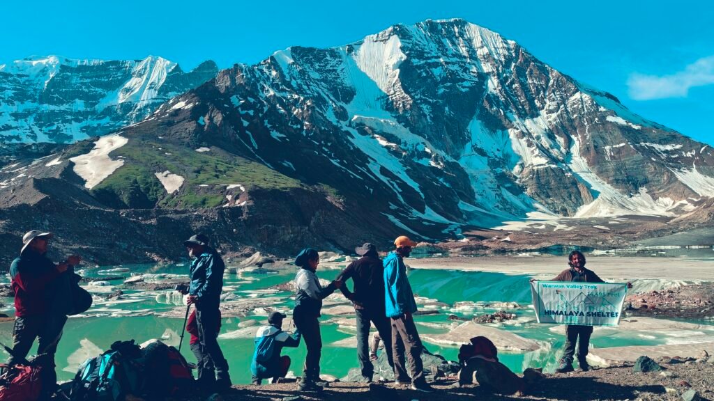
- Maximum Altitude: Gadsar Pass, $\approx 4,200$ m (13,750 ft).
- Start Point: Shitkadi village near Sonamarg.
- End Point: Naranag village (or vice-versa).
- Lakes Covered: Vishansar, Kishansar, Gadsar, Satsar (a cluster of seven small lakes), Nundkol, and Gangbal.
Kashmir Great Lakes Trek Highlights
- The Seven Alpine Lakes (Satsar): Witnessing the stunning, crystal-clear glacial waters of lakes like Vishansar and Kishansar (the twin lakes) from the vantage point of Gadsar Pass.
- Lush, Rolling Meadows: Trekking through endless, vibrant green meadows dotted with countless wildflowers during the peak season.
- Harmukh Peak Reflection: Camping by Nundkol and Gangbal lakes, with the towering, majestic Mount Harmukh ($\approx 5,300$ m) reflected beautifully in their waters.
- High-Altitude Passes: Crossing the challenging but rewarding passes like Nichnai Pass ($\approx 4,000$ m) and Gadsar Pass ($\approx 4,200$ m).
- Diverse Terrain: Experiencing a mix of dense pine forests, rocky boulder sections, glacial streams, and gentle meadows.
📏 Kashmir Great Lakes Trek Difficulty Level
The Kashmir Great Lakes Trek is categorized as Moderate to Difficult.
- Altitude Challenge: The maximum altitude reached is $\approx 4,200$ m at Gadsar Pass, and most campsites are high (3,500 m to 3,900 m), making acclimatization crucial. Acute Mountain Sickness (AMS) is a real risk.
- Terrain: The trail is physically demanding, involving long trekking days (5-8 hours daily), sustained ascents and steep descents, often on uneven, rocky, or sometimes slippery terrain.
- Passes: You cross two to three major high-altitude passes, which involve significant elevation gain and loss in a single day.
- Fitness Requirement: It is not recommended for absolute beginners. Trekkers should have a high level of cardiovascular fitness and endurance, capable of carrying a daypack and walking long distances comfortably for several consecutive days.
🗓️ Best Time to Visit Kashmir Great Lakes Trek
The KGL Trek is accessible for a very short window each year.
| Time Period | Key Features | Recommended For |
| July to Mid-August | Peak bloom of wildflowers, lush green meadows, generally pleasant temperatures (day: 15°C–25°C, night: 5°C–10°C). Occasional rain is possible (monsoon effect). | Best Time for quintessential Kashmiri beauty and vibrant scenery. |
| Mid-August to Mid-September | Weather is more stable, clear skies, meadows begin to turn a beautiful golden/autumnal hue. Colder nights (down to $\approx 0^\circ$C). | Best for clear views and photography, avoiding the peak July crowds. |
| Late June / Early July | Lakes may still be partially frozen, and higher passes like Gadsar Pass may have significant snow patches, making the trek much more challenging and technical. | Experienced trekkers only. |
🗺️ How to Reach the Kashmir Great Lakes Trek
The trek primarily starts from the base village of Shitkadi, which is just a few kilometers before the popular tourist town of Sonamarg.
- By Air: Fly to Srinagar International Airport (SXR), the capital of Jammu & Kashmir.
- Srinagar to Sonamarg/Shitkadi: The starting point, Shitkadi, is located about 80-90 km from Srinagar.
- Shared Taxi/Bus: Available from the Tourist Reception Centre (TRC) in Srinagar to Sonamarg.
- Pre-booked Cab: Most trek operators include the scenic $\approx 3$-hour drive from Srinagar to the base camp (Shitkadi) on Day 1 of the itinerary.
📝 Things to Consider
Health and Safety
- Acclimatization: Spend a day in Srinagar or Sonamarg before starting the trek to help your body adjust to the altitude.
- AMS Prevention: Ascend slowly and stay hydrated. Carry necessary medications like Diamox (consult your doctor).
- Trekking Gear: Invest in good waterproof trekking shoes, multi-layered clothing (thermal wear, fleece, down jacket), and high-quality rain gear. Nights are very cold.
- Communication: Mobile network (especially BSNL) is intermittent and generally unavailable past the first day’s pass (Nichnai Pass).
Logistics
- Local Support: Due to the challenging terrain, long distances, and the need for logistics (tents, food, ponies/porters), it is highly recommended to trek with a local, licensed operator.
- Leave No Trace: The KGL region is extremely fragile and protected. Carry back all non-biodegradable waste.
🛂 How to Get Kashmir Great Lakes Trek Permit
The KGL Trek traverses sensitive zones near the Line of Control (LOC), making a permit mandatory.
- Permit Requirement: A trekking permit is required for all trekkers.
- How to Obtain:
- Through a Trek Operator: This is the easiest and most common method. Your trekking company will handle the complete process, including submitting necessary documents to the local police and forest department in Kangan/Sonamarg.
- Self-Organized: If trekking solo or independently, you must apply to the Tourist Reception Centre (TRC) in Srinagar and then submit the required receipts/documents at the Kangan Police Station for the final pass.
- Documents Needed: Carry multiple copies of a valid Photo ID (Aadhaar Card, Passport, Voter ID) and passport-size photos, as these are frequently checked at various Army Check Posts along the route (e.g., Shekdur, Gadsar).
🥾 Kashmir Great Lakes Trek Itinerary (7 Days/6 Nights)
This is a standard itinerary starting from Sonamarg and ending at Naranag.
| Day | Route | Approx. Distance | Altitude (Max) | Key Highlights |
| Day 1 | Drive Srinagar to Shitkadi, trek to Nichnai | $\approx 10$ km | $\approx 3,500$ m (11,500 ft) | Drive through Sonamarg, trek through dense pine and maple forests. |
| Day 2 | Nichnai to Vishansar Lake via Nichnai Pass | $\approx 12$ km | $\approx 4,000$ m (13,100 ft) | Cross Nichnai Pass, descend to the stunning Vishansar Lake. |
| Day 3 | Vishansar to Gadsar Lake via Gadsar Pass | $\approx 14$ km | $\mathbf{4,200}$ m (13,750 ft) | Highest point of the trek. View of Vishansar & Kishansar from the pass, Gadsar Lake. |
| Day 4 | Gadsar to Satsar | $\approx 11$ km | $\approx 3,600$ m (11,800 ft) | Walk through vast meadows, reach the cluster of Satsar lakes. |
| Day 5 | Satsar to Gangbal / Nundkol Lake | $\approx 9$ km | $\approx 3,500$ m (11,500 ft) | Cross the final ridge, spectacular twin lakes at the base of Mt. Harmukh. |
| Day 6 | Rest Day/Exploration or Gangbal to Naranag | $\approx 13$ km (if descending) | $\approx 2,250$ m (7,400 ft) | Option for rest, or a steep descent through pine forest to Naranag village. |
| Day 7 | Drive Naranag to Srinagar | $\approx 55$ km | $\approx 1,600$ m (5,200 ft) | Visit ancient Naranag temple ruins, drive back to Srinagar. |